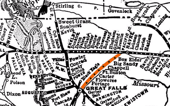
My little piece of the Great Northern models element from the line between Great Falls and Havre, Montana.
My layout is based upon locations along the stretch of the Great Northern Railway between Havre and Great Falls, Montana. Technically the GN identified this route as Section 2 of the Butte Division. This section was built as part of the massive leap west of Minot, ND when the railroad constructed over 900 miles of track westward in 1887. I have chosen to set my modeling loosely in the late fifties to early sixties time period (so I can run those GP-30s purchased in 1964!) There are several very cool prototype features that make this location a great inspiration for modeling:
- Seven quaint little towns with even more grain grain elevators. All of these towns had depots at one time or another and many still exist today.
- River’s edge right of way as well as pure Montana prairie.
- A 900 foot long, tall steel trestle over a large coulee.
- First class passenger train service into the sixties – The Western Star
- Local passenger service via the Empire Builder connection.
- Through and local freight.
- …and believe it or not, a tunnel in the middle of otherwise flat Montana!
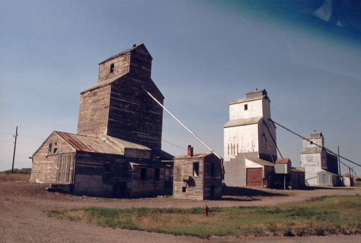 Grain elevators are a plenty along the route. Here in Carter, MT three prairie skyscrapers adorn the otherwise unremarkable horizon.  The Western Star ran over the route from Havre to Great Falls. |
From Rivers Edge to Prairie
The geography of this region is an interesting mix of river bluffs, coulees (valleys) and prairie. The area is fairly arid and vegetation falls off quickly to scrub brush when away from the Missouri river’s edge. As the railroad proceeds to the northeast, a more typical eastern Montana landscape emerges with wide expanses of gently rolling grain fields.
 Just west of Ft. Benton, MT, the GN rides along the bluffs above the Missouri. 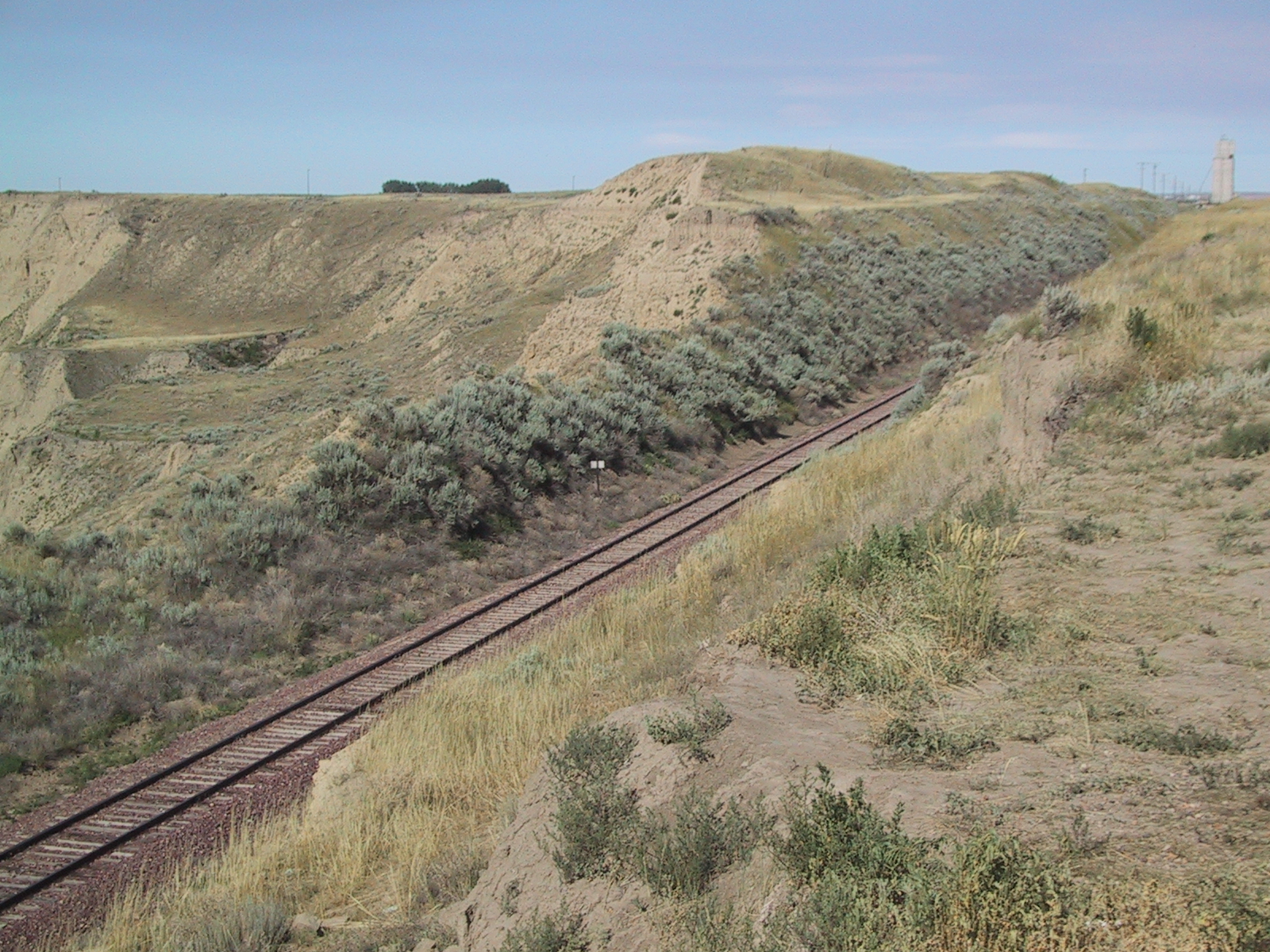 Near Carter, MT, the arid right-of-way is more reminiscent of Southern California. |
Tunnel of Love

I could not believe it when researching for my layout. The USGS map looked like there was a tunnel in a very unexpected place!
While researching the Havre/Great Falls route for my layout, I noticed on the USGS maps a small tunnel a couple miles northeast of Fort Benton, MT. The odd landform is called “Coron du Nez” or “Bridge of the Nose” and was actually noted by Lewis and Clarke on their expedition. It is a ridge that separates the Missouri and Teton river valleys just prior to their convergence at Loma, MT. Railroad engineers apparently decided that it was easier to poke a hole through this soft soil than keep with the winding edge of the Missouri. The tunnel is listed as 527′ long on the Bridge List manifest. I believe the tunnel was added as part of a re-alignment of the route in the 20’s in order to run the railroad much closer to Fort Benton. The original route basically skirted the town as James Hill was unhappy that they would not provide the railroad free land through the town. Hill knew that the town, having become important as the farthest navigable port on the Missouri, would quickly lose its prominence as the railroad replaced river navigation, so he built the railroad around the town. Great for my model because a railroad can’t have enough excuses for hiding track as it exits a scene.
 I was thrilled to find the tunnel and portal intact on a driving vacation in 2003. How many nit pickers would claim a model of a tunnel like this is unrealistic?  It's a short tunnel but its perfect for a model railroad. The portal says it was built in 1923. I believe the tunnel was constructed some 35 years after the railroad first arrived due to a more favorable alignment of trackage for the town of Ft. Benton. |
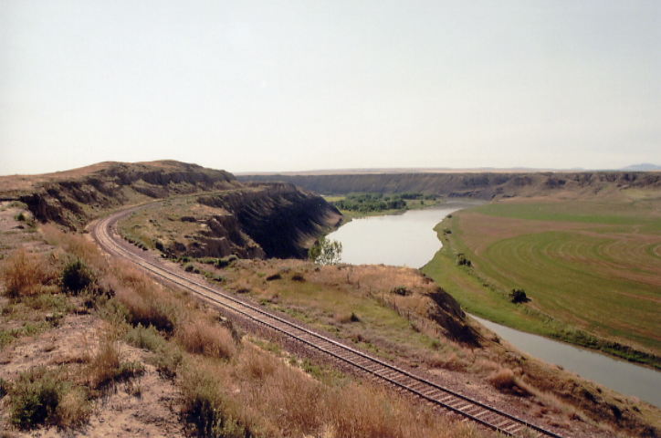
Tall Trestle at Coal Banks Coulee
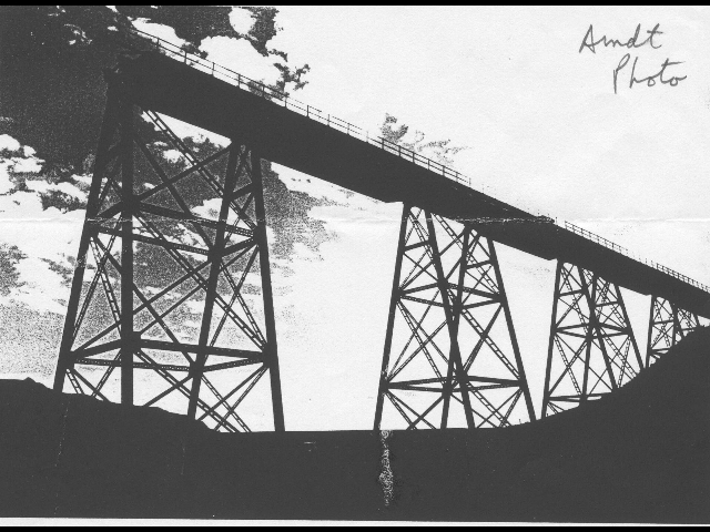
The Coal Banks Coulee trestle provides a great opportunity to include a classic tall steel GN style trestle.
Another modeling opportunity on this line is the tall steel trestle over Coal Banks Coulee. This is a classic GN bridge built in 1900 that was 883 feet long and 94 feet high. Check out my article on how I built a scaled down model of this bridge for my layout. The real bridge was torn down in the late seventies as the center portion of the line was abandoned.
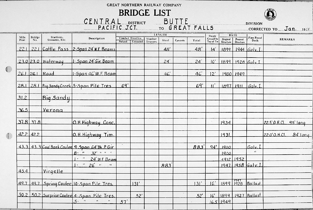
This GNRY Bridge List denotes some of the bridges on the Havre to Great Falls route, including the trestle over Coal Banks Coulee
Prairie Towns

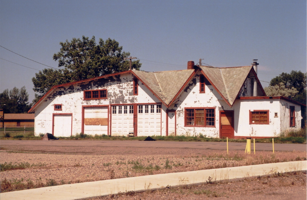
The Ft. Benton depot is unusual and far from the standard designs. Hmm, might have to fudge that on my layout.
The run from Great Falls to Havre is dotted with seven small towns and at least fifteen grain elevators. All had depots at one point in time and several remain in place or around town in 2003. Fort Benton and Big Sandy were large enough to justify the service of the Western Star passenger train to add to operation interest. We can’t model then all but we can take our favorite elements from them to produce some great scenes and models.
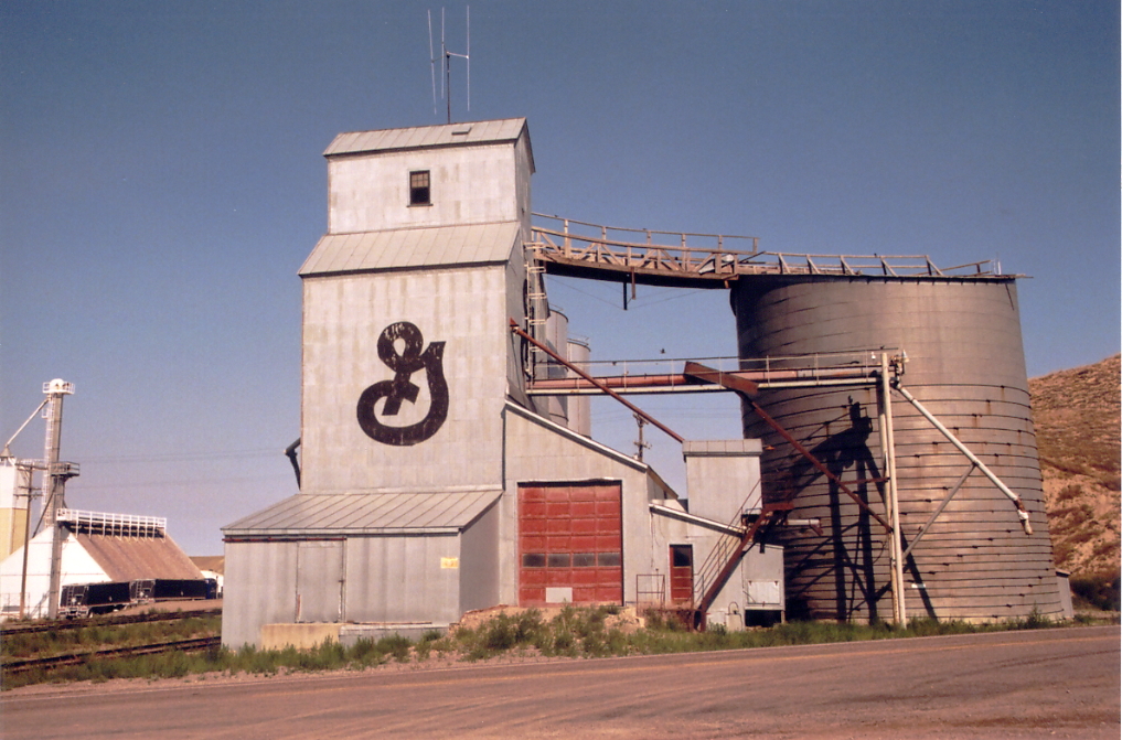
Here is the grain elevator in Ft. Benton.
This unusual structure appears to be an old service station. It is located in Ft. Benton.
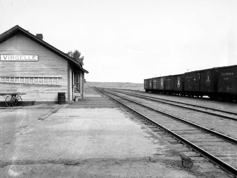
Here is a shot of the tiny town of Virgelle, MT, just south of the Coal Banks bridge, in 1924. The town consisted of a depot, a grain elevator and not too much more.
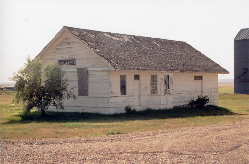
The Carter depot, a classic GN standard design, was still standing in 2003.
| . |
Freight & Passenger Operations
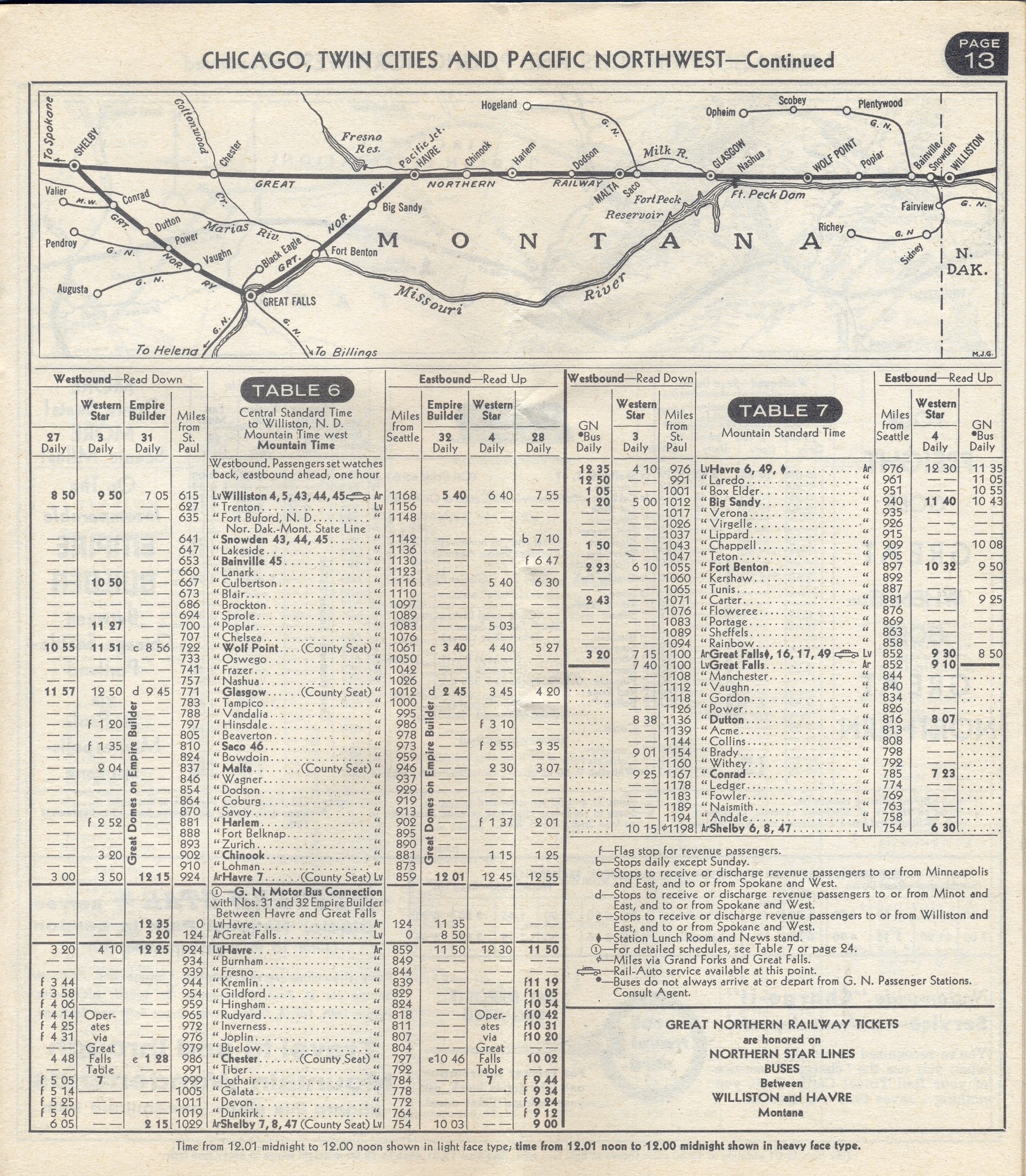
The Western Star is arguably the second great passenger train on the great Northern behind the Empire Builder. This is the 1962 timetable.
As the Great Northern expanded west in the late 1800’s, the line from Havre to Great Falls was the mainline. By the time the late fifties rolled around the majority of traffic by-passed this stretch of track and made its way over the “High Line” to Great Falls via the division point in Shelby, MT. Still the Havre/Great Falls route did see a sizeable amount through freight, local freight service to the dozen or so grain elevators and other businesses, local passenger service and GNRY’s number two passenger train, the Western Star.
Train control was by schedule and orders. No signals were ever installed on the line so need to buy that expensive Digitrax signaling system.
XXXSee GNRHS Data Sheet extensively reviews the passenger activity through Great Falls, MT and is a great source of information regarding passenger traffic between Great Falls and Havre.
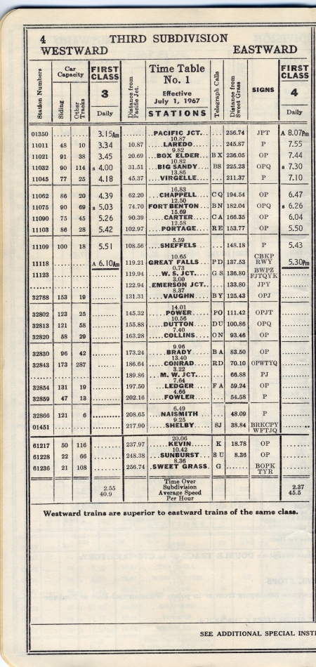
The 1957 Employee timetable indicate a daily east and west freight, local passenger and the daily Western Star.
The Western Star ran until 1970 when Amtrak took over passenger from the Burlington Northern.
The GN’s flagship passenger train, the Empire Builder, did not run on this line but did stop in Havre. Train 237/239 unofficially called the Empire Builder Connector provided service to Havre passengers to Great Falls in coordination with the Empire Builder arrivals. This train was reduced to a bus run when the Western Star
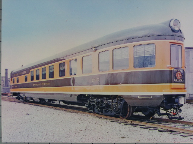
This Appekunny Mountain observation car was similar to the same cars that we run on the Western Star.
We will have plenty to keep us busy running local and through freights while staying out of the way of the Western Star.
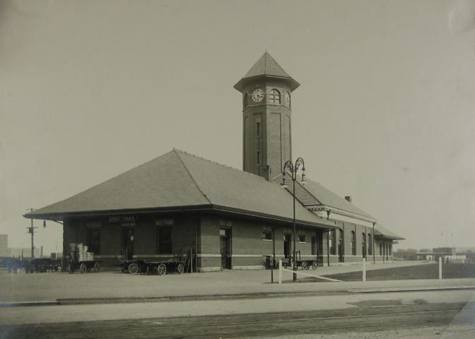
Great Falls, MT, the southern terminus of our inspiring line, sported an impressive brick station the serviced the fairly active passegner service from points north and south.


Looking forward to visiting Havre !
Eileen
Very nice! I just moved to montana from Illinois and follow the line all the way up from helena to Harve. I saw the tunnel you write of , right of off rt.87 neet line in general. I just followed the same line from Helena down to butte. very cool the GN depot still stands in Butte. Can you tell me where I can more info on this line? what about pics? can you tell me when the line was abandoned frm helena to butte? I also noticed that between Harve and great falls it has been pulled up about 20 miles south of Harve then there is a big chunck of it in place in the middle then the south part is pulled up to great falls. How does the BN acess the middle part? Hope to hear from you soon! Mickey